
Community
New region-wide survey will allow Liverpool residents to find the best phone coverage in their area
1 year ago
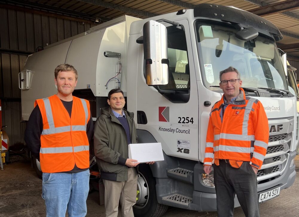
Bin lorries are to be used in a landmark project to measure the mobile phone signal at every home and workplace across the Liverpool City Region.
The region-wide survey in Liverpool will allow residents to check coverage at their home, on the commute and at work before they sign up to a deal.
The mapping exercise is the latest in a series of measures funded by the Combined Authority aimed at making Liverpool City Region one of the best digitally connected regions in the UK. The six-month project begins this month in Knowsley and will roll out across the other five council areas one by one.
Under the plan, mobile analysts Streetwave will install measuring devices in recycling trucks and road sweepers to continually assess signal strength and data speeds from the four main service providers during their rounds. Portable trackers will be used in hard-to-reach areas.
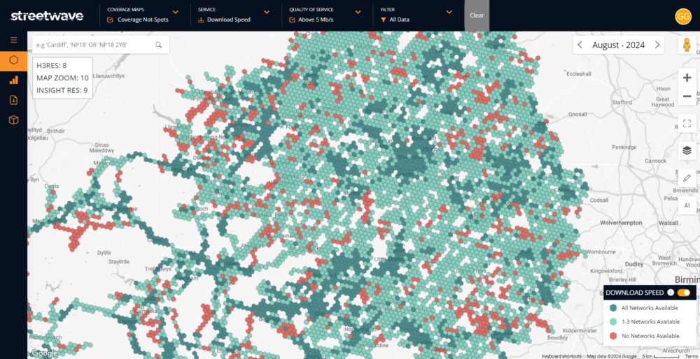
The scheme will produce a free, interactive map showing in detail how mobile providers perform down to street level.
It will also identify mobile phone ‘not-spots’ that may require help to improve local mobile coverage and network capacity.
Mayor of the Liverpool City Region Steve Rotheram said:
“Any successful, modern city region needs first-class digital infrastructure – and since I was elected Mayor, I’ve made it a priority to make our region the most digitally connected area in the UK, already investing tens of millions of pounds in LCR Connect.
“Good mobile coverage isn’t a luxury – it’s a necessity for work, travel, and daily life. But too many people still struggle with poor signal and slow data speeds.
“This initiative will give people across our region the information they need to choose the best provider for them – while helping us identify areas that need better coverage, so no community is left behind.”
The survey will be carried out using local authority waste collection vehicles as a cost-effective way to assess coverage down to address level.
Detection units comprising four mobile phones will be placed on board, each linked to one of the main four UK providers – EE, O2, Three, and Vodafone.
For inaccessible areas, such as beaches, paths and shopping centres, walking surveys will be done using portable units to measure connectivity.
The mobile connectivity mapping will create a visual overview of of coverage and capacity in an area, showing signal strength, upload and download speeds and the frequency (2,3,4 or 5G) being used.
It is estimated that each council area will be mapped in 4-6 weeks, after which residents and local businesses can check and compare mobile coverage across the areas where they live and work.
Find more information on the Liverpool City Region Combined Authority website.
Find all the latest Liverpool news here.
The Guide Liverpool Editorial Team
The Guide Liverpool proudly shares regular stories from in and around Liverpool. From the latest news, to the best what’s on listings. Our editorial team is made up of trained journalists and media professionals, meaning you will never miss a moment from the city region.


 Subscribe
 Follow Us
 Follow Us
 Follow Us
 Follow Us